B.1 Beaver Creek Mine Discharge Area Case Study
Ottawa County, Oklahoma
Acknowledgments
The mining team would like to acknowledge Tim Kent of the Quapaw Tribe of Oklahoma in Quapaw, Oklahoma who submitted the Biochemical Reactors Case Study.
B.1.1 Site Information
Contact
Tim L. Kent, PG
Environmental Director
Quapaw Tribe of Oklahoma
PO Box 765
Quapaw, OK 74363
918-542-1853
Name, Location, and Site Description:
Beaver Creek mine discharge area, located 1 mile southeast of Quapaw, Oklahoma
Lat/Long: 36o 56’ 09” N; 94o 45’ 09” W
Elevation: 855 ft.
The Beaver Creek Mine discharge area is near Quapaw, Oklahoma and within the Tar Creek Superfund site, a historical lead and zinc mining area within what is known as the Tri-State Mining District, which covers approximately 2500 square miles in northeast Oklahoma, southeast Kansas and southwest Missouri. Mining began in the Tar Creek area in the early 1900s and continued until the late 1960s using underground room and pillar extraction methods. Galena and sphalerite were the primary lead and zinc ore minerals respectively, mined from Mississippian aged limestone and shale formations. The Tar Creek site was placed on the National Priorities List (NPL) in 1983.
Many of the Mississippian formations mined in the Beaver Creek area, particularly the Boone formation, are aquifers; consequently, the mining operations required continuous dewatering. Once mining ceased in the Beaver Creek watershed in the 1920s, the abandoned mine voids began filling with groundwater, and in some cases surface water, until the mines began discharging water at the surface, and ultimately into Beaver Creek a short time after mine dewatering ceased. Beaver Creek flows through Quapaw Tribal lands that are historically and culturally significant to the tribe.
B.1.2 MIW Chemistry
As mentioned, upon cessation of last mining operations within the Tar Creek site, groundwater began to accumulate in the mine voids. By late 1979, metal-rich waters had begun to discharge, via artesian pressure, into Tar Creek (mine discharges into Beaver creek began much earlier due to the much earlier cessation of mining in this area). These discharges, containing elevated concentrations of iron, zinc, lead, cadmium and arsenic, cause significant degradation of stream water quality. Until 2008, no full-scale treatment of any of these discharges was attempted. In 2008, with grant funding provided by the USEPA Region 6 Water Quality Division to the University of Oklahoma, a full-scale semi-passiveRequiring some mechanical and/or energy to operate such as timed valves ort dosing pumps, but not major pieces of equipment. treatment system, receiving approximately 150 gallons/minute of contaminated mine water, was constructed to address mine water discharges to an unnamed tributary to Tar Creek, on the Mayer Ranch property near Commerce, OK (approximately 5 miles west of Beaver Creek). This system, consisting of a series of specifically designed process units, has been operational since late 2008 and successfully decreases contaminant concentrations (Nairn et al. 2010a; Figure 1; Table 1).
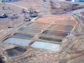
Figure B.1-1. Oblique aerial photo of existing passive Mayer Ranch treatment system showing multiple process units.
|
Parameter |
In |
Out |
|---|---|---|
|
pH |
5.95 |
7.11 |
|
Net alkalinity (mg/L as CaCO₃) |
29 |
224 |
|
Iron (mg/L) |
192 |
0.44 |
|
Zinc (mg/L) |
11 |
0.45 |
|
Cadmium (µg/L) |
17 |
<DL* |
|
Lead (µg/L) |
60 |
<DL |
|
Arsenic (µg/L) |
64 |
<DL |
|
Sulfate (mg/L) |
2239 |
2057 |
|
*DL – Detection Limit |
||
Three monitoring projects in the Beaver Creek watershed (Nairn 2003; Sutter 2008; Nairn et al. 2010b) have identified several mine water discharges (Figure B.1-2) demonstrating considerably lower, yet substantial, contaminant concentrations and discharge rates than those found at the Mayer Ranch property (Table B.1-2). Beaver Creek flows through the tribal pow-wow grounds, as well as through other culturally and historically significant tribal Lands. In-stream surface water quality and biological indicators of ecosystem health are impaired in Beaver Creek (Iverson 2003; Clifton 2009; Nairn 2003; Nairn et al. 2010b). Based on results at the Mayer Ranch BCR system, at-the-source management and/or treatment of these Beaver Creek area discharges would likely result in significant watershed-scale improvements.

Figure B.1-2. Beaver Creek mine discharge locations.
Aerial photograph of a portion of the Beaver Creek watershed, showing main stem of creek and tributaries, abandoned mine water discharges and open mine shafts. The Quapaw tribal pow-wow grounds are located directly downstream of these contaminated inputs.
Table B.1-2 compares untreated mine water characteristic for existing Mayer Ranch passive treatment system inflow, and Beaver Creek discharge site 8 (see Figure 2 above). Concentrations of contaminants of concern and discharge rates are considerably lower for the Beaver Creek discharge relative to the inflow into the Mayer Ranch property treatment system, while pH and alkalinity are higher, indicating the likelihood of effective semi-passive treatment of Beaver Creek area discharges.
|
Parameter |
Mayer Ranch PTS Influent |
Beaver Creek Site |
|---|---|---|
|
pH |
5.95 |
6.62 |
|
Net alkalinity (mg/L as CaCO₃) |
29 |
90 |
|
Iron (mg/L) |
192 |
9.28 |
|
Zinc (mg/L) |
11 |
1.60 |
|
Cadmium (µg/L) |
17 |
1 |
|
Lead (µg/L) |
60 |
15 |
|
Arsenic (µg/L) |
64 |
20 |
|
Sulfate (mg/L) |
2239 |
244 |
|
Flow rate (gallons/minute) |
150 |
25 |
B.1.3 System Design
B.1.3.1 BCR Design
Although the design of the BCR for mine discharges at Beaver Creek is not complete, the design will be similar to that of the Mayer Ranch BCR (multiple process units in series as shown in Figure 3). However, issues specific to the Beaver Creek area MIWs, such as multiple sparsely distributed mine discharge points and intermittent flow characteristics, will have to be addressed during the design phase.
B.1.3.2 Pre and Posttreatment requirements
The Beaver Creek area water treatment system is anticipated to consist of multiple process units, in series, with at least one BCR process unit. Therefore, similar to the Mayer Ranch treatment system, the inflow to the Beaver Creek area treatment system will likely employ some form of oxidation and sediment settling processes before being routed to the BCR unit; and it is anticipated that outflow from the BCR unit will be routed through a re-aeration pond, a horizontal limestone bed unit, and a final aerobic polishing unit before the water is allowed to discharge at the end of the series of treatment units (Figure 3).
B.1.4 Regulatory Challenges
As mentioned, most tribes have established Environmental Departments funded primarily by USEPA. As with states, USEPA can delegate programmatic authority to tribes for Environmental programs, including regulatory authority under the Clean Water Act, if the tribe applying for such authority has an established Environmental Department and satisfies other USEPA requirements. Consequently, many tribes have developed enforceable Water Quality Standards. Although the Quapaw Tribe has developed its own Water Quality Standards, they are not yet enforceable until the tribe receives programmatic authority from USEPA. However, the tribe has been in close communication with those designing the Beaver Creek area BCR regarding the tribe’s Water Quality Standards, which reflect the tribe’s priorities in addressing surface water contaminants. Although the BCR may have the effect of treating water that meets Oklahoma Water Quality Standards, the Quapaw Tribe may not view the resulting water quality as being protective of the tribe, considering the tribe’s more intensive use of water and water related resources.
B.1.5 Stakeholder Challenges
The Beaver Creek BCR is proposed to be constructed on Quapaw tribal land that is culturally and historically significant to the tribe. It is referred to as the Catholic 40 property by the tribe. In the late 1800s, the Catholic Church built an Indian school and church on this property so that Quapaw children could attend the school instead of being sent off to far away Indian schools, as was the Bureau of Indian Affairs policy for children of other Native American tribes during this period of Indian Assimilation. There is also a tribal cemetery on this property and members practice traditional subsistence and cultural gathering of plants along Beaver Creek in this area. Finally, Beaver Creek flows through the Quapaw Tribe’s pow-wow grounds immediately downstream of the proposed BCR. Tribal members gather various food and ceremonial resources along Beaver Creek during the annual pow-wow and the creek plays an important part in their cultural and religious practices. Consequently, it has been extremely important to seek input from the tribal leaders and the tribe’s environmental Department (like States, most tribes now have Environmental programs funded by USEPA) early on in the conceptual design of the BCR and certainly before the initiation of any field investigations.
Most Native American tribes have a different perception of environmental protection and remediation than that of western European or modern American societies. Therefore, it is very important to approach the tribe(s) that may be affected by the proposed BCR, and initiate a consultation process before beginning even the conceptual design. Federally Recognized Tribes and USEPA have jointly developed consultation policies and procedures to be used before environmental regulations or actions, that may affect tribes, are initiated. Therefore, it is highly recommended that those proposing BCRs on, or near, tribal lands or in areas of tribal jurisdiction, contact the appropriate USEPA Regional office and ask for office of the USEPA tribal liaison official who will likely offer detailed guidance on the appropriate tribal consultation procedures.
Regarding the proposed Beaver Creek BCR, the following step-by-step procedure was followed to incorporate tribal input into information and data gathering related to the proposed BCR:
- Dr. Robert Nairn of Oklahoma University was encouraged by USEPA to contact the Quapaw Tribe Environmental Department to discuss the possibility of beginning data gathering involved in investigating the feasibility of constructing a BCR in on the Catholic 40 property in the Beaver Creek area.
- Tim Kent, Quapaw Tribe Environmental Director, approached Quapaw Tribal leaders to explain the general concept of a BCR (using the Mayer Ranch BCR as an example) and to inquire about the possibility of collecting the data necessary to adequately evaluate the feasibility of constructing and operating a BCR in the Beaver Creek area.
- After asking many questions regarding the effects of the BCR and its construction and maintenance, the Quapaw Tribal Business Committee reluctantly approved the initiation of data gathering and monitoring related to the BCR feasibility study, contingent on the assurance that no historic or culturally significant areas or features would be disturbed during the data collection activities (the Quapaw Tribe, like many native American tribes, believe that man cannot fix Mother Earth once man has severed the sacred connection between the two; therefore, the tribe is very skeptical about the value in attempting the construction of a BCR).
- Assessment and mapping of historic and culturally significant features on the Catholic 40 property, where the sampling and construction related to the proposed BCR is planned, was undertaken by the tribe’s Historic Preservation Officer (THPO).
- Upon the assurances from the THPO and the tribe’s Environmental Director that sampling and construction related to the proposed BCR would not adversely affect any historic or culturally significant features, the Tribal Business Committee granted approval to initiate the design of the BCR. Once a draft of the design is complete, it will be presented for approval to the Tribal Business Committee.
B.1.6 Other Challenges and Lessons Learned
The primary lesson learned during the planning of the Beaver Creek BCR was: when considering the design and construction of a BCR, entities should investigate the likelihood that the BCR would affect tribal lands by contacting the liaison office of the appropriate USEPA Region. If the BCR is planned for an area near, or upstream of, tribal lands, the potentially affected tribe should be consulted using USEPA/tribal guidance.
B.1.7 References
Clifton, J. 2009. Using Rapid Bioassessment to Measure Biological Quality of Streams in Northeastern Oklahoma, University of Oklahoma MS thesis, 72 pp.
Iverson, N.J. 2003. Ecological Assessment of Three Oklahoma Streams Impacted by Mine drainage, University of Oklahoma MS thesis, 264 pp.
Nairn, R.W. 2003. Beaver Creek Passive Treatment System Design, Final Report to U.S. Army Corps of Engineers, 122 pp.
Nairn, R.W. J.A. LaBar, K.A. Strevett, W.H. Strosnider, D. Morris, C.A. Neely, A. Garrido, B. Santamaria, L. Oxenford, K. Kauk, S. Carter, B. Furneaux. 2010a. A Large, Multi-Cell, Ecologically Engineered Passive Treatment System for Ferruginous Lead-Zinc Mine Waters. Mine Water and Innovative Thinking, Proceedings, International Mine Water Association, Sydney, Nova Scotia, Canada, pp. 255-258.
Nairn, R.W. 2010b. Source, Transport and Fate of Mine Waste Contaminants at the Tar Creek Superfund Site, Draft Final Report to U.S. Geological Survey, approximately 1000 pp.
Reed E.W., S.L. Schoff, C.C. Branson. 1955. Ground-water Resources of Ottawa County, Oklahoma. Oklahoma Geological Survey Bulletin 72, 203 pp.
Sutter, A. 2008. A Hydrological Study of Mine-surface Water Distribution and Interactions in the Beaver Creek Watershed, Ottawa County, OK. University of Oklahoma, MS thesis, 218 pp.
U.S. Environmental Protection Agency. 2010. Tar Creek (Ottawa County) Oklahoma Superfund Fact Sheet, EPA ID# OKD980629844, Site ID 0601269, USEPA Region 6, Dallas TX. Available at http://www.epa.gov/superfund/accomp/factsheets08/tar_creek.htm, 6 pp.
Publication Date: November 2013